If you are considering drilling a borehole, one of the first questions you will probably ask is whether your property actually has groundwater below it. That is a sensible place to start. Boreholes can be a valuable long-term investment for South African homeowners, but drilling without understanding the signs and context can lead to expensive disappointment.
The good news is that groundwater often leaves clues on the surface. These clues do not guarantee a successful borehole, but they can point you in the right direction. A greener patch of land, thriving deep-rooted trees, persistent dampness, nearby successful boreholes, and certain slope or drainage patterns may all suggest that underground water is present or moving nearby.
At the same time, it is important to be realistic. Groundwater is not always easy to predict from the surface alone. A property can show promising signs and still yield a weak borehole. Another property may show almost no obvious clues and still produce strong, reliable groundwater. The purpose of this guide is not to give false certainty. It is to help you understand what to look for, what those signs mean, and when it is time to bring in a professional.
If you are still early in your research, it also helps to read how borehole drilling works step by step. Understanding the drilling process makes it easier to judge whether your property is worth investigating further.
In this guide, you will learn the most common signs your property may have groundwater, how geology and topography influence water below ground, the difference between useful clues and misleading myths, and how to move from observation to a smarter borehole decision.
Table of Contents
- What groundwater is
- Why surface signs matter
- The main signs your property may have groundwater
- Vegetation signs to watch for
- Soil and moisture signs
- Terrain and landscape clues
- What nearby boreholes can tell you
- What the signs do not prove
- How professionals confirm groundwater potential
- Should you drill if the signs look good?
- Final thoughts
- FAQs
What Groundwater Is
Groundwater is water stored below the surface in the spaces between soil particles, in weathered rock, and inside fractures or cracks in rock formations. In most parts of South Africa, groundwater forms when rainfall infiltrates the ground instead of flowing away completely as surface runoff.
Many people imagine groundwater as a huge underground lake. In reality, that is usually not how it works. More often, the water is held inside underground materials and formations. A borehole taps into these water-bearing zones and allows the water to be pumped to the surface.
This distinction matters because a property can technically have groundwater underground without having enough usable groundwater to justify a borehole. When you ask whether your property has groundwater, the real question is usually this:
Does your property have accessible groundwater in a quantity and quality that makes drilling worthwhile?
That is why visible signs are useful, but they need to be interpreted carefully. The goal is not simply to find any moisture underground. The goal is to identify whether there may be a practical water source worth developing.
Why Surface Signs Matter
Groundwater often affects what happens above ground. That influence can show up in vegetation patterns, moisture retention, soil behaviour, seepage zones, and the way certain parts of a property respond to dry weather.
For example, when shallow groundwater sits closer to the root zone, some patches of grass may stay green longer than the rest of the yard. In other cases, a slope may develop a persistent wet band where water slowly emerges from underground. On rural properties, certain lower-lying areas may consistently show stronger growth, softer soil, or moisture-loving plants.
These signs matter because they help you narrow your attention. They do not replace professional assessment, but they can help you answer important early-stage questions:
- Does this property show any promising groundwater indicators?
- Which area seems more favourable than the rest?
- Should I gather more information before drilling?
- Is it worth speaking to a driller or hydrogeologist?
Think of surface signs as clues, not conclusions. One clue means little on its own. Several clues together become much more useful.
The Main Signs Your Property May Have Groundwater
1. Certain Areas Stay Green for Longer
One of the most common signs is a patch of land that remains greener than the surrounding area, especially during dry periods. If a section of lawn, veld, or pasture consistently holds its colour better than the rest, it may be benefiting from better subsurface moisture.
This can happen because groundwater is shallower there, because underground water movement feeds the area, or because the soil retains water more effectively. However, it can also be caused by irrigation leaks, shade, soil differences, or runoff concentration. That is why you should look for repeated natural patterns rather than a once-off observation.
2. Deep-Rooted Trees Are Unusually Healthy
Large, vigorous trees can be a useful indicator of underground moisture, especially when they appear healthier in one part of the property than elsewhere. Trees with deeper root systems may be accessing moisture below the surface even when topsoil conditions are dry.
Clusters of healthy trees can sometimes point to:
- a fracture zone below ground
- better subsurface moisture movement
- a natural recharge area
- a lower zone where water accumulates
This sign becomes more meaningful when the vegetation pattern seems too strong to be explained by normal rainfall alone.
3. Damp or Soft Ground Returns in the Same Area
If a certain section of the property repeatedly stays soft, damp, or boggy long after rainfall has passed, that can be a clue. Repeated moisture in the same area may suggest shallow groundwater, slow seepage, or a low point where underground water movement affects the soil.
Still, damp soil is not always a borehole indicator. It may simply reflect poor drainage or clay-heavy soil. The stronger the pattern, and the more other signs appear alongside it, the more useful this clue becomes.
4. Seepage Appears on a Slope or Embankment
One of the clearest signs of subsurface water movement is seepage. This usually appears as a narrow wet band, darkened soil, moss growth, or lush vegetation on a slope, cut bank, or embankment.
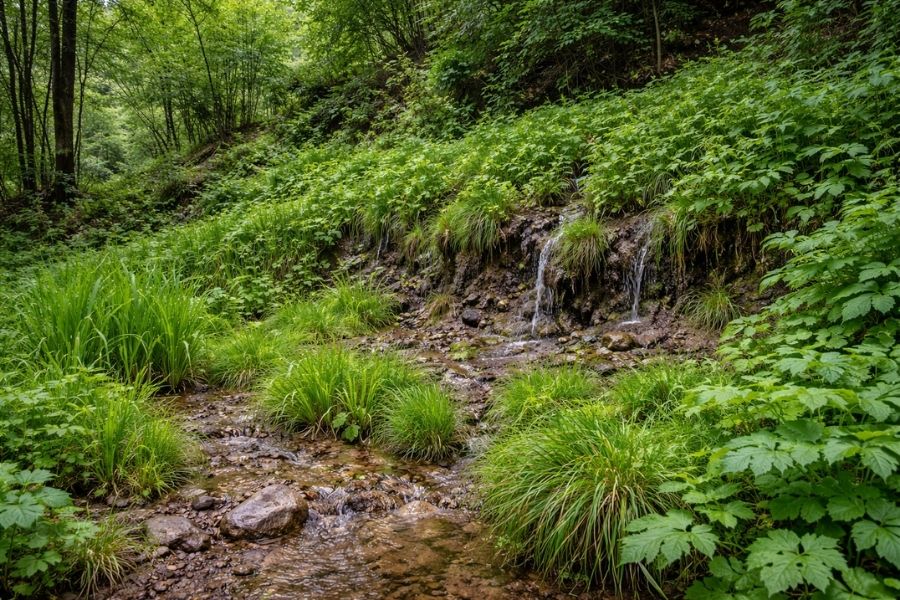
A seep can form when underground water moves through a soil or rock layer and emerges at the surface where conditions change. This does not guarantee a strong, sustainable borehole yield, but it is often a meaningful clue that water is present and moving underground nearby.
5. Water Collects in the Same Place After Rain
If water repeatedly gathers in the same natural part of the property after rain and takes a long time to dry out, that area may deserve closer attention. It could indicate a low point, a shallow water table, or slower underground drainage. It may also simply reflect compacted or clay-rich soils.
The key is pattern. If a naturally low zone keeps collecting water over multiple seasons while nearby areas dry out quickly, it may be telling you something about how water behaves on and below your land.
Vegetation Signs to Watch For
Plants often reveal underground conditions better than people do. On properties without formal irrigation, vegetation patterns can be one of the easiest ways to identify possible groundwater influence.
Greener Grass or Natural Groundcover
A greener patch is one of the first signs homeowners notice. If the greener zone seems stable over time, and not linked to a garden tap, irrigation line, gutter outlet, or shade pocket, it may indicate better moisture below the surface.
Moisture-Loving Plants
Reeds, sedges, rushes, and similar moisture-preferring plants often appear where shallow water or persistent soil wetness exists. If these plants are growing naturally, without deliberate planting or watering, they may point to groundwater influence.
Dense Growth in a Narrow Line
Sometimes vegetation grows more strongly in a line rather than a broad patch. This can happen above underground fractures or water pathways. A narrow band of stronger vegetation may be worth noting, especially in rocky or sloping terrain.
Trees Thriving in a Specific Zone
When a cluster of trees looks much healthier than the rest of the property, particularly in dry months, that area may have better access to underground moisture. This can be especially useful on larger plots and smallholdings.
Even so, vegetation should never be read in isolation. Plant performance can be influenced by sunlight, species, topsoil, fertilisation, and runoff. It is strongest when it supports other signs you have already noticed.
Soil and Moisture Signs
Soil behaviour can also reveal hidden water conditions.
Persistent Softness Underfoot
If one section of your property remains noticeably softer than nearby ground, especially after the rest has dried, this may indicate shallow moisture. In some cases, that moisture may be related to groundwater rather than surface runoff alone.
Darkened Soil That Reappears
Repeated darker patches of soil may indicate persistent dampness. This is especially worth noting where there is no visible irrigation, no leaking infrastructure, and no obvious reason for localised wetness.
Recurring Damp Smell or Coolness
In some cases, a moisture-prone area may have a consistently cooler feel or earthy damp smell compared to surrounding parts of the property. While subtle, these observations can sometimes support other visible clues.
Seasonal Wet Patches
Some properties show wet patches every year in the same place after rain season. This can indicate poor drainage, but it can also reflect groundwater interaction with the near-surface soil profile.
Where these signs appear in combination with slope seepage, greener vegetation, and nearby boreholes, they become much more valuable.
Terrain and Landscape Clues
Groundwater is heavily influenced by topography. The position of your property in the landscape often matters as much as what you see on the ground.
Low-Lying Areas
Valley bottoms, natural hollows, and lower foot slopes are often more promising than ridges or exposed high points. Water generally moves downslope, both on the surface and below it, so lower zones often collect or receive more subsurface moisture.
Drainage Lines
If your property sits near a natural drainage line, that may indicate a pathway for recharge and subsurface water movement. These areas often deserve attention, although contamination and flood risks must also be considered before drilling.
Foot Slopes Below Higher Ground
A foot slope below rising terrain can sometimes be a favourable zone because it may receive water moving down from upslope areas. These transition zones can be especially interesting where rock structures or fractures help channel underground flow.
Rock Outcrops and Fracture Zones
In many South African hard-rock environments, groundwater is stored in fractures and weathered zones. Visible fracture lines, changes in rock type, and aligned depressions may hint at where water can move or accumulate underground. Most homeowners will not interpret these features accurately on their own, but they are useful details to point out during a site inspection.
| Landscape Position | Typical Groundwater Implication |
|---|---|
| Ridge top | Often less favourable because it drains quickly and may be more exposed |
| Mid-slope | Variable, depending on fractures and subsurface conditions |
| Foot slope | Often more promising because it can receive downslope moisture |
| Valley bottom | Can be favourable, but also needs contamination and flooding checks |
| Drainage line | May indicate recharge and subsurface water pathways |
What Nearby Boreholes Can Tell You
One of the strongest practical indicators is local borehole success. If nearby properties have working boreholes, your chances generally improve. This does not guarantee that your property will produce the same result, but it is far more useful than guesswork alone.
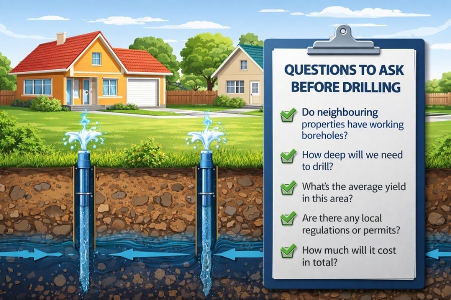
If you can, try to find out the following about neighbouring properties:
- How deep their boreholes are
- Whether they produce water year-round
- What the approximate yield is
- Whether the water quality is good
- Whether they needed filtration or special treatment
- Whether a survey was done before drilling
If multiple nearby properties have productive boreholes, especially at similar depths, that is useful local evidence. If nearby boreholes are deep, weak, unreliable, or have poor water quality, that is also useful information.
This is why it helps to understand the cost side as well. If the local area usually requires deeper drilling, you should also review how much borehole drilling costs per meter in South Africa before making decisions.
Historical Water Use Matters Too
Old wells, windmill sites, spring-fed areas, and local stories about groundwater can also offer clues. On older rural properties, historical water use sometimes tells you more than the surface appearance alone.
What the Signs Do Not Prove
This is the part many property owners skip, and it often leads to disappointment. Surface signs can be useful, but they do not prove all the things people assume they do.
A Green Patch Does Not Guarantee a Strong Borehole
It may indicate shallow moisture, but that moisture could be limited, perched, seasonal, or unrelated to a productive water-bearing formation.
Damp Soil Does Not Mean Unlimited Water
Persistent wet ground might reflect poor drainage or a clay lens rather than a sustainable groundwater source.
One Successful Neighbour Does Not Guarantee Success Next Door
Groundwater can vary over short distances, especially in fractured rock areas. Local success improves the odds, but it does not remove risk.
No Surface Signs Does Not Mean No Groundwater
Some successful boreholes are drilled on properties with few obvious visual clues. The absence of signs does not automatically mean the property is unsuitable.
Water Divining Should Not Be Your Only Method
Some people trust divining, but if you are making a real financial decision, it is wiser to combine practical observation with geological understanding, local data, and professional input.
How Professionals Confirm Groundwater Potential
Once surface signs suggest that your property may be worth investigating, the next step is to move beyond guesswork.
1. Site Inspection
A driller or hydrogeologist may assess vegetation, slope, drainage, access, contamination risks, and the general layout of the property. They may also identify a more suitable drill point than the one a homeowner first considered.
2. Local Borehole and Geological Review
Professionals often draw on local knowledge, borehole history, and regional geology. In many cases, this information is more valuable than surface appearance alone.
3. Geophysical Survey
Where appropriate, a geophysical survey may help identify subsurface structures, fracture zones, and more promising groundwater targets. It does not guarantee success, but it can improve borehole siting.
4. Drilling and Yield Testing
Ultimately, drilling is the real test. Once the borehole is drilled, yield testing helps determine how much water it can sustainably produce.
5. Water Quality Testing
Even a successful water strike is only part of the story. Water quality testing is important if the borehole will be used for household supply, drinking water, irrigation, or livestock.
Before you commit, it is also smart to understand the full financial picture. A borehole is not just a drilling cost. There may also be pump installation, piping, electrical work, filtration, storage, and ongoing maintenance. That is why many homeowners should also review the total cost of installing a borehole at home before moving ahead.
Should You Drill If the Signs Look Good?
Promising signs are a reason to investigate further, not a reason to assume guaranteed success.
You may be in a good position to explore drilling if:
- nearby properties have successful boreholes
- your property shows repeated moisture or vegetation clues
- the landscape position looks favourable
- there is no obvious contamination risk near the proposed drill site
- your budget covers the full borehole setup, not just drilling
You should be more cautious if:
- there is little local evidence of successful boreholes
- the area is known for deep or low-yield boreholes
- you are relying entirely on the borehole with no backup water plan
- you have only budgeted for drilling and not the rest of the installation
- the most promising area is close to septic systems or contamination sources
Simple Property Checklist
| Possible Sign | What to Look For |
|---|---|
| Greener patch | Stays healthier than surrounding ground in dry weather |
| Healthy deep-rooted trees | Strong growth in one specific zone without obvious irrigation |
| Persistent damp ground | Returns repeatedly in the same place after rain |
| Seepage on slope | Wet band, moss, or lush growth on a bank or embankment |
| Low-lying terrain | Natural hollow, foot slope, or drainage path |
| Moisture-loving plants | Reeds, rushes, sedges, or similar plants growing naturally |
| Nearby boreholes | Neighbouring properties with working groundwater supply |
| Historical water use | Old wells, springs, windmill sites, or established groundwater use |
The more of these signs you can tick off, the stronger the case for taking the next step. But none of them should be treated as a guarantee on their own.
Final Thoughts
So, what are the clearest signs your property has groundwater?
Usually, it is not one dramatic clue. It is a combination of clues that starts to form a pattern. A greener patch of land. Trees that stay healthy through dry spells. Damp or soft soil that returns in the same place. Seepage on a slope. Low-lying terrain. Moisture-loving plants. Nearby successful boreholes. Historical evidence of groundwater use.
That pattern can give you confidence that your property is worth a closer look. But confidence is not the same thing as proof. The smart approach is to use these signs as a screening tool, then move to better evidence through local data, expert advice, and proper assessment.
For BoreholeGuide readers, that is the right way to think about groundwater. Not as a mystery solved by guesswork, and not as something that can be guaranteed from surface clues alone, but as a practical decision that becomes clearer when you combine observation, local knowledge, and professional evaluation.
If your property shows several of the signs in this guide, you may have a worthwhile groundwater opportunity. The next step is to investigate it properly and weigh the costs, risks, and long-term value before drilling.
FAQs
Can you tell if a property has groundwater just by looking at it?
No, not with certainty. You can identify signs that suggest groundwater may be present, but you cannot confirm a productive borehole from surface appearance alone.
What is the strongest sign of groundwater on a property?
Nearby successful boreholes are often one of the most useful practical indicators. On the property itself, seepage, recurring damp zones, and persistent vegetation patterns can also be strong clues.
Does a green patch mean I should drill there?
Not automatically. A green patch can indicate moisture, but it may also be caused by irrigation leaks, shade, or soil differences. It is a clue, not proof.
Are low-lying areas always better for groundwater?
Not always, but they are often more promising than exposed high ground because water tends to move downslope. However, they must still be checked for contamination and practicality.
What if my property shows no obvious signs?
That does not necessarily mean there is no groundwater. Some successful boreholes are drilled where there were very few visible surface indicators.
Should I get a survey before drilling?
In many cases, yes. A professional assessment or geophysical survey can help improve siting and reduce risk, especially where drilling costs are high.
What should I do before paying for drilling?
Check nearby borehole history, study your property’s terrain and moisture patterns, speak to experienced local drillers, understand full installation costs, and consider professional advice before committing.